Launch Watch · professional_archive_workflow
Published
GOES-U, GOES-19 and GOES East: one satellite, three dated labels
Resolve GOES-U and GOES-19 against five real commissioning milestones, and separate first-image acquisition, public release and the GOES East handover.
GOES-U, GOES-19 and GOES East describe different parts of one satellite’s history. GOES-U was the launch-era name. GOES-19 became the spacecraft’s name in orbit. GOES East was an operational role it took over later.
That distinction matters when a search result, image caption and operations record seem to disagree. The answer is to resolve the name against a dated event, then keep acquisition, release and operational status in separate fields.
Follow the spacecraft through five milestones
NASA’s launch release records GOES-U launching on June 25, 2024. NOAA’s first-imagery article says it was renamed GOES-19 when it reached geostationary orbit on July 7. The same NOAA article describes an ABI image acquired on August 30 and released publicly on September 18. It labels the testing-phase imagery preliminary and non-operational.
NOAA’s April 7, 2025 operations announcement records GOES-19 replacing GOES-16 as GOES East. The NOAA calibration-event log gives the transition time as 15:10 UTC. These records describe a historical commissioning sequence; they are not a claim about today’s constellation assignment.
| Event date | Record to search | Identity or role | What the date means |
|---|---|---|---|
| Jun 25, 2024 | Launch release | GOES-U | Launch event |
| Jul 7, 2024 | NOAA first-imagery account | Renamed GOES-19 | Arrival in geostationary orbit and naming transition |
| Aug 30, 2024 | ABI 16-channel panel caption | GOES-19 | Image acquisition; scans began around 18:00 UTC |
| Sep 18, 2024 | First-imagery article | GOES-19 | Public release date |
| Apr 7, 2025, 15:10 UTC | Calibration-event log | GOES-19 becomes GOES East | Operational handover |
A worked lookup: the August 30 image
Suppose your question is which spacecraft acquired the first-light panel shown in the September article. Begin with the image’s acquisition date, August 30. The rename had already occurred on July 7, so GOES-19 is the relevant spacecraft name. Retain GOES-U as a historical alias for related launch documents.
Next, separate the article date from the observation date. September 18 identifies the public release in this record. Searching an imagery archive only for September 18 could lead you to observations from the wrong day, even if the spacecraft identifier is correct.
Did the first-imagery release establish that GOES-19 was already GOES East?
No. NOAA explicitly described the testing imagery as preliminary and non-operational. The separate April 7, 2025 announcement establishes the later GOES East transition. Preserve both statements with their own dates rather than applying the later role backward to every earlier image.
This is a documentary lookup method. No two-file archive join was tested here. Before joining actual data files, inspect each file’s platform identifier, observation time, product description and quality or processing metadata. A familiar public-facing name is a starting point, not a substitute for those fields.
What the four intervals can tell you
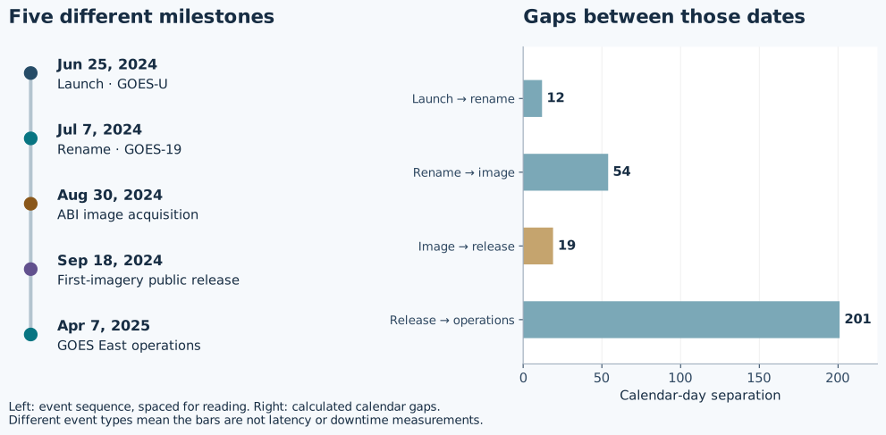
Calendar subtraction gives 12 days from launch to rename, 54 from rename to the selected image acquisition, 19 from that acquisition to public release, and 201 from public release to operational handover. The attached chart deliberately labels each pair of endpoints.
Only the 19-day interval connects this image’s acquisition with this public release. Even that gap is not a measurement of the instrument’s processing latency: the record does not establish when the underlying image product first became available. The 201-day gap connects a communications milestone to an operations milestone and cannot be read as downtime.
The endpoint labels keep the arithmetic useful. Without them, a chart of four durations would encourage comparisons between unlike processes. Here the calculation answers a modest question: how far apart were these documented dates?
Keep location and projection fields distinct too
The operational entry in NOAA’s calibration log gives GOES-19’s position as 75.2° west while stating that its Level 1b imagery was projected from 75.0° west. Those are separately labeled fields in the same record.
If two metadata values differ, first check what each describes. Replacing the projection value with the platform location because they “should match” would erase a distinction the provider intentionally records. This article does not derive a navigation correction or evaluate calibration performance from the difference.
For this commissioning history, the durable search key is the spacecraft identity plus an event date and event type. Keep GOES-U as the launch-era alias, GOES-19 as the post-rename spacecraft name, and GOES East as the dated operational role. That small amount of structure prevents an image release from becoming an accidental operations claim.