Launch Watch · Launch Watch · Evidence study
Published
ISS northbound equator crossings: 93 minutes apart, 24 degrees west
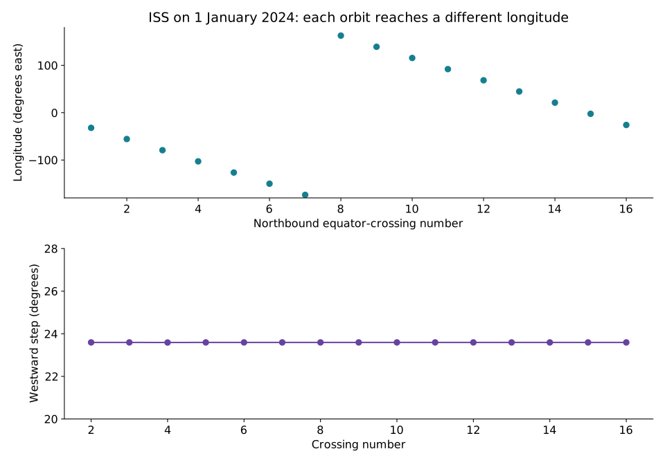
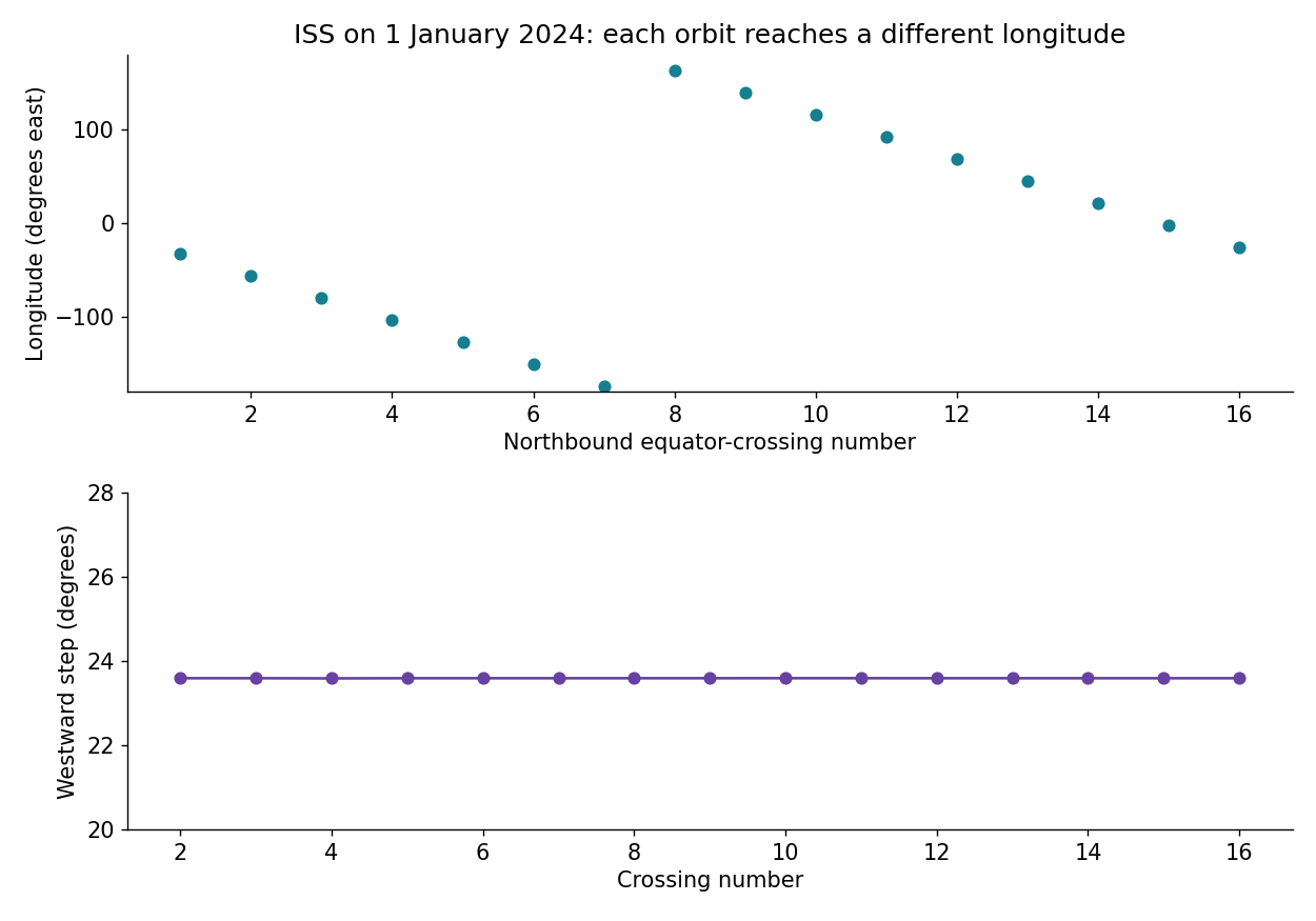
Historical SSCWeb positions put ISS northbound equator crossings about 92.84 minutes apart on 1 January 2024, with each crossing about 23.59° farther west.
On 1 January 2024, the ISS’s first northbound equator crossing in our sample is near 32.07° W. The next is near 55.67° W, about 93 minutes later. The station has returned to the same latitude and direction of travel, but it is crossing over a different longitude.
Using NASA SSCWeb’s historical one-minute positions, we identify 16 northbound equator crossings. The 15 intervals between them average 92.844 minutes, and the westward shift averages 23.594 degrees. This is a worked example of why another orbit does not simply repeat the same ground track.
Open full-size figure · Download PNG figure
Use the same kind of crossing each time
A spacecraft can cross the equator heading north or south. This comparison uses only south-to-north crossings, often called ascending crossings. Comparing successive crossings without keeping their direction would mix different parts of the orbit.
The positions are in SSCWeb’s Earth-fixed geographic coordinates. Longitude describes where the station is relative to Earth’s surface, whose orientation changes while the spacecraft moves. The repeating northbound crossing therefore occurs above a different longitude.
This calculation measures the combined relative motion. It does not separately estimate Earth’s rotation and the orbit’s nodal precession. Nor is the measured ascending-crossing interval identical in definition to a Keplerian period in an inertial frame.
| Crossing | UTC, about | Longitude (degrees east) |
|---|---|---|
| 1 | 00:02 | -32.07 |
| 2 | 01:35 | -55.67 |
| 3 | 03:08 | -79.26 |
| 4 | 04:41 | -102.85 |
| 5 | 06:14 | -126.44 |
| 6 | 07:47 | -150.04 |
| 7 | 09:19 | -173.63 |
| 8 | 10:52 | 162.77 |
| 9 | 12:25 | 139.18 |
| 10 | 13:58 | 115.59 |
| 11 | 15:31 | 91.99 |
| 12 | 17:04 | 68.40 |
| 13 | 18:37 | 44.80 |
| 14 | 20:09 | 21.21 |
| 15 | 21:42 | -2.38 |
| 16 | 23:15 | -25.98 |
The longitude jump is a display boundary
After the crossing near 173.63° W, the next lies near 162.77° E. On a longitude axis from −180° to +180°, that looks like a large jump. Following the globe across the date-line meridian shows the same roughly 23.59-degree westward step.
To calculate that displacement, we unwrap longitude before interpolation and wrap the final reported position back into the familiar range. Simply subtracting displayed longitude labels across the boundary would produce a misleading large difference.
From one-minute samples to crossings
The SSCWeb request covers 00:00 UTC on 1 January through 00:00 UTC on 2 January 2024. Including both endpoints gives 1,441 samples at 60-second cadence.
We find adjacent geographic-latitude samples that bracket zero from south to north. Linear interpolation estimates the fraction of the minute at which latitude reaches zero, and we apply that fraction to time and unwrapped longitude. Consecutive estimated crossing times and longitudes then give the interval and shift.
The source cadence limits the interpretation of those interpolated digits. The table rounds times to approximately the nearest minute. Additional decimal places retained in the calculation CSV support reproducibility, not a claim of millisecond observational accuracy.
Historical modeled geometry has a specific use
SSCWeb’s provenance record identifies its ISS source as definitive, TLE-derived data updated weekly. These are modeled orbit positions, not independent visual sightings. The source’s “definitive” label should remain attached to that provenance, rather than being read as proof that someone observed each plotted crossing.
The example can explain a shifting ground track. It cannot predict a current visible pass, establish illumination or show whether the station was above a particular observer’s horizon. Those questions require the relevant current geometry and viewing conditions.
The reusable lesson is to retain the frame, crossing direction and observation period beside the number. “Northbound equator crossings averaged 92.844 minutes apart in this 1 January 2024 sample” is much more precise than treating 93 minutes as a promise to return over the same place. See observing spaceflight for the broader evidence context.
Sources and data
Source snapshots were retrieved on 6 October 2026. The observation dates and product versions are stated above; retrieval does not make a historical record current.
Download B442_iss_geo_samples.csv (CSV) · Download B442_iss_equator_crossings.csv (CSV)